
Screenshots


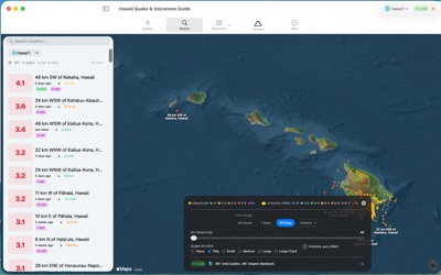


About Hawaii Quake & Volcanoes Guide
Aloha!
This real-time earthquake & volcano monitoring app focuses on Hawaii Island’s three active volcanoes: Kilauea, the most active volcano in the world; Mauna Loa, the largest active volcano on Earth: Hualalai, perhaps the most mysterious volcano in Hawaii; the dormant volcano Mauna Kea & the possible next island Kamaehuakanaloa (Loihi). After the, try before you buy (no credit card required), 2 day free trial, the app requires an active subscription or lifetime purchase
Custom Alerts:
Real-time notifications can be set for earthquake and volcano activity like magnitude, lava flows, fountains, swarm activity, tilt, depth & proximity which offer clues to timing events. Essential for anyone wanting to be in the right place, at the right time.
Built for residents, researchers, educators, travelers, hikers, photographers, emergency planners, and anyone fascinated by Hawaii geology, Hawaii Earthquakes helps you move beyond rumors, headlines & see what's happening now.
Track the latest seismic activity with live USGS-based data:
- Live HVO cams for Kilauea, Mauna Loa, Mauna Kea, & Hawaii Volcanoes National Park
- Magnitude, depth, and location for each event
- Fast access to recent events across Hawaii Island & worldwide.
Big Island focus - 3 ways to explore the subsurface:
1. Cross-Section View
Vertical slices through the island show epicenters, hypocenters, & underground structures
2. Spinning Island View
Rotate slowly thru 360 view of Big Island & below to compare surface &, deeper quakes, & cross-sections from different angles.
3. 3D Point Cloud View
Explore using a fast (thanks to Apple Silicon) interactive 3D point cloud of earthquake activity below the island surface to see where events cluster in space and time
Visualization and analysis features:
- 3D globe with depth exaggeration and color-coded magnitude
- Adjustable time ranges including 24 hours, 7 days, and 30 days
- Large, resizable windows for close inspection on laptops & large displays. Perfect app to get the big picture of seismic & volcanic events on, around & below Big Island on big monitors
- Map view, search, useful stats, including counts, average magnitude, & max magnitude by time window
- Kilauea tilt data for additional eruption context
- Region filters for Hawaii, Big Island, Big Island plus Kamaehuakanaloa (Loihi), & worldwide activity
Why people use Hawaii Earthquakes & Volcanoes
- Residents want fast local awareness
- Curious visitors want context before exploring the island
- Researchers & students want a clear visual tool
- 471 surprising FAQs about earthquakes, volcanoes, Hawaiian geology, and island history
Hawaii Earthquakes is also a great companion for anyone interested in lava, rift zones, calderas, earthquake swarms, volcanic tilt, magma movement, hotspot geology, & the birth of the Hawaiian Islands. It is a practical island tool, a geology viewer, & a living science window into one of the most active volcanic regions on Earth
Great for island life & field use:
- Check activity before hiking, sightseeing, camping, boating, diving, or visiting Volcano
- Watch earthquake sequences develop near Kilauea, Mauna Loa, or offshore south of Hawaii
- Timeline history of each volcanoes eruptions.
- Use the app as a daily volcano & earthquake dashboard for the Big Island
Whether you are a local keeping an eye on home, a visitor planning an unforgettable trip, or a researcher following seismic clues, Earthquakes Hawaii turns raw seismic data into a clearer, more visual, more useful experience
Built for research, education, exploration, travel, & the question almost everyone asks:
When will Kilauea erupt next?
This is only the beginning. More features are on the way
We welcome ideas, questions, bug reports & additions. Contact us through the app
Mahalo
Privacy policy: https://plumamazing.com/legal#privacy
The app uses Apple's standard End User License Agreement (EULA): https://www.apple.com/legal/internet-services/itunes/dev/stdeula/
AVALW Coverage
Not yet mentioned in AVALW articles.
Similar apps


 The Weather Channel - RadarThe Weather Channel InteractiveThe Weather Channel is the World's Most Accurate Forecaster*. In addition to our daily forecasts, hourly details, and 24-Hour Future Radar, you can also persona★ 4.8 6064k


 Weather Radar - Meteored NewsMeteoredWeather Forecast, Trending News, Hurricane & Storm Tracker, Alerts & Live Radar.★ 4.7 3064k


 AccuWeather: Weather RadarAccuWeatherYour local weather forecast, storm tracker, radar maps & live weather news★ 3.6 2574k


 WeatherBug: Weather ForecastWeatherBugDownload the most popular free weather app powered by the largest professional weather network in the world! Enjoy Free access to 10-Day Forecast and over 140 h★ 4.8 2187k


 WeatherAppleWeather keeps you informed about conditions including temperature, rain, snow, and wind. Check out the forecast by the hour for the next ten days. Use maps to h★ 4.8 1838k


 weather24: Forecast & Radarwetter.com Group GmbHLive weather tracking anytime, anywhere with accurate rain radar forecasts★ 4.7 1653k


 Weather - By XiaomiXiaomi Inc.Always with you, rain or shine. Get temperature, forecast, AQI for you city.★ 4.1 1291k


 1Weather Forecasts & RadarOneLouder AppsHyperlocal Forecasts, Live Radar, Severe Weather alerts & Homescreen Widgets★ 4.3 1114k
More by this developer


 World Clock Alarms Cal iClockPlum Amazing Software LLCOldest & most popular menubar world clock/calendar. Enhances Productivity Looks stunning in Mac OS Mojave Dark Mode iClock replaces Apple's old menubar clock ap-


 OMradio.sgPlum Amazing Software LLCOMradio is Singapore's First Hindu Devotional Radio. OMradio has popular devotional songs from all eras, interesting information, thought-provoking snippets and★ 5.0 2


 Hawaii Quake & Volcano GuidePlum Amazing Software LLCAloha! This real-time earthquake & volcano monitoring app focuses on Hawaii Island’s three active volcanoes: Kilauea, the most active volcano in the world; Maun★ 5.0 3


 Public Speaking S Video AudioPlum Amazing Software LLCTurns an iPhone or iPad into your personal mobile speech podium. Create, archive, rehearse, hear, record in Audio/Video, present, time and give speeches. Speech★ 1.7 3