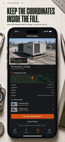
PREMIUM — PURCHASE REQUIRED: All features described below are part of Pro and require a purchase: a weekly or yearly auto-renewing subscription, or a one-time lifetime purchase. Take photos that prove where and when they were taken. GPS Map Camera burns a location stamp — address, GPS coordinates, date, time and a map thumbnail — into the pixels of every shot, and writes the same fix into the JPEG's GPS EXIF, so your photo carries its evidence on its face and in its file. Most stamp cameras will quietly invent a reading rather than admit they lost the signal. GPS Map Camera is built for people whose photos get checked: when there is no usable GPS fix the stamp says so instead of guessing, horizontal accuracy in metres is printed right on the card, and manually labelled places are visibly marked as manual. What the stamp claims is what the device actually measured. WHAT YOU GET • A finished proof photo in one tap — address, coordinates, date, time and map already burned in before you leave the spot • GPS written into the file itself, so mapping and photo software places the shot exactly where you stood • Three stamp styles: Basic card, Advanced with decimal + DMS coordinates and altitude, Compact one-liner for clean shots • Saved places for recurring jobsites — the right label appears automatically whenever you are back inside its radius • A camera made for the field: 3×3 / 4×4 grids, full / 1:1 / 9:16 / 3:4 framing, self-timer, tap to focus, flash — and you drag the stamp to the corner you want • A built-in gallery of every capture, plus one-tap export to Photos with add-only permission PERFECT FOR • Contractors and site engineers documenting progress, defects and deliveries • Inspectors, surveyors and adjusters who need photos that stand up to review • Field service and delivery teams proving arrival at the right address • Anyone clocking in with a photo — the when and where are already on it WHY NOT JUST USE THE NORMAL CAMERA? Your iPhone already geotags photos — invisibly. That hidden metadata is stripped the moment the photo goes through most messengers, uploads and job platforms. A burned-in stamp survives every share, every compression, every screenshot, and can be read by a client or inspector without any special tool. GPS Map Camera gives you both: the visible stamp that survives, and the GPS metadata for software that respects it. PRIVATE BY DEFAULT Location is used only while the app is open, your captures stay on your device, and the app only ever asks for add-only access to your Photos library — it cannot browse what is already there. Remember: a stamped photo reveals its own location, so share it deliberately. PREMIUM (PURCHASE REQUIRED) GPS Map Camera Pro unlocks the Advanced and Compact stamp styles, decimal + DMS coordinates and GPS altitude on the visible stamp, and removes the app mark from your exports. Full access is available as a weekly subscription, a yearly subscription, or a one-time lifetime purchase. Open it at the site gate, shoot once, and walk away with the proof already on the picture. Terms of Use: https://leanstudio.asia/terms-of-use Privacy Policy: https://leanstudio.asia/privacy-policy Support: support@leanstudio.asia
Photo & Video · iPhone, iPad · Free