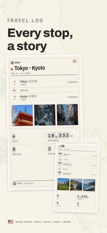
RCAP finds the trips already sitting in your photo library, and draws each one as a map worth printing. It reads the dates and coordinates your camera saved, works out where one trip ended and the next began, and assembles the route — the days, the stops, the distance. Nothing to log, nothing to tag, nothing to fill in. FIVE WAYS TO PRINT ONE TRIP Sheet — the dense one: every stop named, the photographs counted, a tally for each day. Trek — the route as the subject: numbered stops, with the distance and the time on every leg. Plain — the ground lettered like an atlas, edge to edge. Pin — your photographs standing on the map at the coordinates they were taken. Text — the itinerary as plain text, for pasting into a message. The paper turns with the journey: a trip down a coastline comes out landscape, a weekend in one city comes out portrait. THE PASSPORT Every country you have stood in, stamped on one page and read over a chart of the world. SHARING Send a print straight to Instagram Stories, or copy a trip's index and paste it onto a background of your own. ON YOUR DEVICE Your photos never leave your device. There is no account to create, and no server holds your library — the trips, the maps and the prints are all made on the phone. Street-level maps for a country are downloaded the first time you open a trip there, and can be deleted again in Settings. RCAP PRO Takes the RCAP mark off the footer of a print. Monthly, yearly, or bought once. Map data © OpenStreetMap contributors, ODbL. Terms of Use (EULA): https://silverai.com/rcap/term/
Travel · iPhone, iPad · Free